Report reveals extent of town's flood chaos


The details have been revealed in a flood impact report produced by the region’s authorities which also highlight future prevention measures.
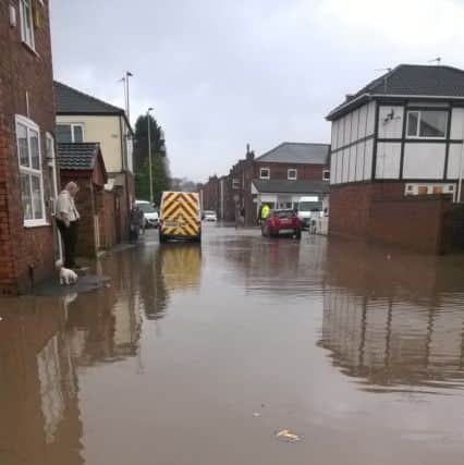
Almost 93 properties were left waterlogged and more than 4,200 homes left without power after torrential rain over night on Christmas Day and Boxing Day.
Advertisement
Hide AdAdvertisement
Hide AdThe investigation report - published by the Greater Manchester combined authority - states flood protection reviews are taking place across the borough by the Environment Agency.
Tony Lloyd, Mayor of Greater Manchester, said: “This report demonstrates the importance of working together across GM to solve our common problems.
“Last December, Greater Manchester agencies and communities came together magnificently to assist residents and defend property across the region from unprecedented flooding.
“Now, we’re working together again to understand the floods and ensure that we are better equipped to deal with future incidents.”
Advertisement
Hide AdAdvertisement
Hide AdWigan Council has obtained funding to improve drainage on Elmridge in Lowton, the report adds.
And investigations are ongoing in areas of Abram, Bickershaw, Platt Bridge and Hindley.
The River Douglas reached 2.55m, one metre “higher than any other reading in its 38 years of records, and had risen 1.4m in the two hours and 15 minutes before the peak level, which came at 2.15pm on Boxing Day.
A rain gauge at Worthington, near Standish, registered 66mm of rainfall in a 24 hours period, the report adds.
Advertisement
Hide AdAdvertisement
Hide AdThe Evening Post revealed earlier this year the clean-up operation in Wigan borough was estimated to have cost the council more than £1m.
The deluge, caused by Storm Eva, meant Latics’ fixture against Sheffield United was postponed with areas around the DW Stadium underwater.
Across the region more than 2,250 homes and 500 businesses were affected with a further 31,000 hit by power shortages.
Damage to infrastructure has cost £11.5m, regional authory bosses said.
Advertisement
Hide AdAdvertisement
Hide AdAnd 37 out of 44 river gauges across the region recorded their highest ever levels with between 70 to 100mm in 24 hours.
But a rapid response from regional authorities saved around 2,500 from the impact of rising water levels.
The statutory report has been published on behalf of the eight affected boroughs of Greater Manchester, the Environment Agency and United Utilities. It recommends risk management authorities continue to work in partnership with each other and with communities in the future.
Coun Rishi Shori, GMCA lead for Civil Contingencies, said: “The Boxing Day floods caused widespread damage across the region and it is important that we work together and do all we can to prevent this happening again in future.
“I would encourage everyone who lives in areas at risk of flooding to sign up to the Environment Agency’s free Floodline early warning service, which will inform you if a flood is likely.”
•