
A closer look at the 6 massive sites in Wigan borough where the council wants 5,340 new homes to be built

There are six sites for housing identified in the draft local plan.
A strategic plan which will guide Wigan’s future development over the coming decades is coming into focus.
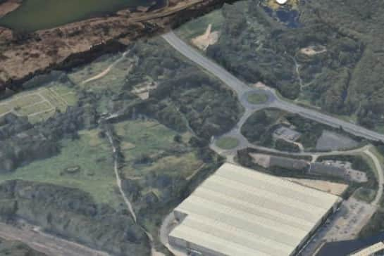

The borough’s local plan, a draft of which is currently out for public consultation, will provide the framework for development for the next 15 years.
The plan points out sites where homes, shops, factories and roads can be built, highlights parks, wildlife habitats and historic places that must be kept safe from building and looks ahead to plan for future population growth.
The draft of the local plan has created a stir for what has been left out, with four sites removed from earlier strategic development plans.
The document greenlit for public consultation excludes development of The Bell, north of junction 26 of the M6, the Moss Industrial Estate extension, land west of Winwick Lane in Lowton, and the Bridgewater West allocation, which would have seen former greenbelt land in Astley allocated for a business park.
Coun Paul Kenny, cabinet holder for planning, environmental services and transport, said the change of heart came after “listening to feedback” from local communities.
He said: “We are aware of the depth of feeling surrounding these four sites. By removing them from the latest version of the local plan, we believe we have struck the right balance between supporting economic growth and protecting our environment.”
That leaves the plan with six strategic sites for housing.
Wigan Council said those have also been subject to changes to policy following feedback.
It said that included the south of Hindley site, which proposes up to 2,000 homes.
The changes state a new link road must be funded and programmed before any homes are built. A full investigation and mitigation measures regarding land contamination will be undertaken for the site.
The public consultation began on Wednesday and runs until 5pm on Wednesday, October 21.
Here we examine the six major areas for development.
Westwood Park (420 homes and employment space)
The draft local plan states the 58-acre brownfield site is suitable for around 420 homes and modern employment space.
The huge plot was home to Westwood power station, which closed in 1986.
The site is bounded by the west coast mainline railway to the east, A49 Westwood Way with the alignment of the proposed Wigan-Hindley link road and Westwood Lane to the south.
The majority of the site is cleared, with the exception of three buildings, of which one is grade II-listed, a substation and surface car parking near office buildings.
North Leigh Park (1,500 homes and new local centre)
At around 65 hectares, North Leigh Park is described as a “key brownfield site in the borough that has been despoiled by previous activities including coal mining, quarrying, tipping and sewage treatment”.
It has been partly reclaimed by nature and used informally for dog walking and other activities.
The plans states it is of limited economic and social value relative to its potential.
The remaining land is allocated for around 1,500 homes.
The development will include a new local centre with “a range of commercial uses and community facilities” to serve the new homes and existing residents, and the delivery of a link road from the A578 Leigh Road to the A579 Atherleigh Way.
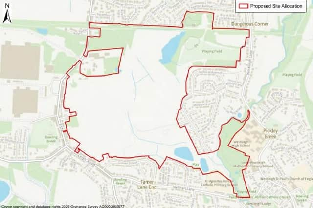
South Hindley (2,000 homes and new local centre)
The site is predominantly brownfield land, reflecting a legacy of coal mining on site.
It is approximately 121 hectares and comprises open land, playing fields, footpaths, small businesses and Leyland Park.
The site is split between several land owners, with Wigan Council and Peel Land being the largest.
The most notable topographic features are two colliery spoil heaps.
The draft plan states the land is allocated for a “residential-led development and supporting infrastructure and facilities to form a sustainable urban extension”.
Up to 2,000 homes are proposed.
Development will be required to deliver a new local centre, comprising commercial uses and community facilities, and to deliver a link road from the A58 Liverpool Road to the A578 Leigh Road.
The plan states an updated masterplan for the scheme is being prepared and “it is anticipated that it will be determined in 2027”.
South of Atherton (270 homes)
The 20.3 hectare site is to the east of Millers Lane and is a mix of brownfield and greenfield land, with a historic mining legacy, with open grassland in grazing and agricultural use.
Lodge Farm is located centrally within the site and Chanters Brook runs through, as does a public right of way linking Lodge Road to Millers Lane.
It is allocated for residential development of around 270 homes.
East of Atherton (600 homes and industrial development)
The site is 39.2 hectares and the draft plan describes the land as “poor semi-improved neutral grassland fields”.
It has multiple land owners including Tarleton Estates, Bellway Homes and Wigan Council.
The land is allocated for residential and employment development comprising around 600 homes and the potential extension of Chanters industrial estate.
A large part of the site is currently subject to a planning application for outline permission for up to 550 homes.
Landgate, Ashton (550 homes)
The site is around 39 hectares of predominantly greenfield land to the south of Landgate Lane and north of Bryn Road.
The draft plan said existing character of the area is predominantly residential.
A green waste management business and Landgate School lie in the north-western part of the site, while Bryn Recreation ground is at the southern extent and Landgate fishing ponds are towards the north.
The land is allocated for around 500 homes.
Bellway Homes will shortly be submitting a detailed planning application for residential development.
Landgate School and the employment premises will be retained or appropriately replaced.
Development will be required to extend new road Bryn Green Avenue, from the A49 Wigan Road through to the B5207 Bryn Road.
The fishing ponds will be safeguarded and their settings enhanced.
Playing pitches at Bryn Recreation Ground will be retained or re-configured, and enhanced, including the provision of changing facilities and car parking.